
North vs south park blocks
street grid differences
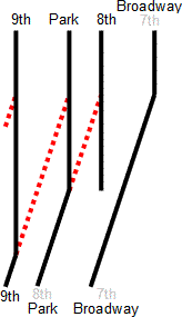
Differences in the streets between Broadway and 9th Avenue in the Northwest/Southwest Portland, Oregon (downtown area), showing that there is one more block when going east/west in NW (around the North Park Blocks) then there is in SW (around the South Park Blocks). Made by me, Jason McHuff, in Microsoft Word 2002 ("XP") and converted to a Windows Metafile using Microsoft PowerPoint and then Scalable Vector Graphics using OpenOffice.org. Finally, extensively cleaned up using Inkscape and a text editor.
The black lines represent actual north/south streets; the red dashed lines show how the streets should line up/connect if they were to be the same distance from the start of the grid. Also, note that addressing is not affected as there are no buildings between NW 8th and NW Park.